Come mid-July, I was feeling like I needed to get some wiggles out. My favorite wiggling partner, Matt, had bailed on me (very out of character for him), so I found myself on the cusp of the weekend with no partner and no plans. The previous weekend (while we were on the Ptarmigan Traverse), Matt had run a cool loop over Daniel to Hinman and back via Venus Lake.
What vindictive plan could I execute solo that would make Matt ashamed for bailing on me? Do the same thing he did, but go farther and tag more summits, of course! Naturally, though, my penchant for photography meant that it would need to be an overnight trip (not to mention my vastly inferior cardio, relative to Matt’s). I was excited to try and go fast and light, covering some distance while exploring one of the most beautiful parts of the Alpine Lakes Wilderness, an area that I had never been in before.
I packed the bare minimum of camping gear into my trail running vest along with four slices of Costco cheese pizza and my little point and shoot camera and drove up the Cle Elum River on Saturday afternoon. It being a nice weekend, the 4x4 folks were out in full force, and I saw the most Toyota 4Runners I’ve ever seen, while simultaneously having the fewest returned waves to other drivers. Coincidence? Probably…
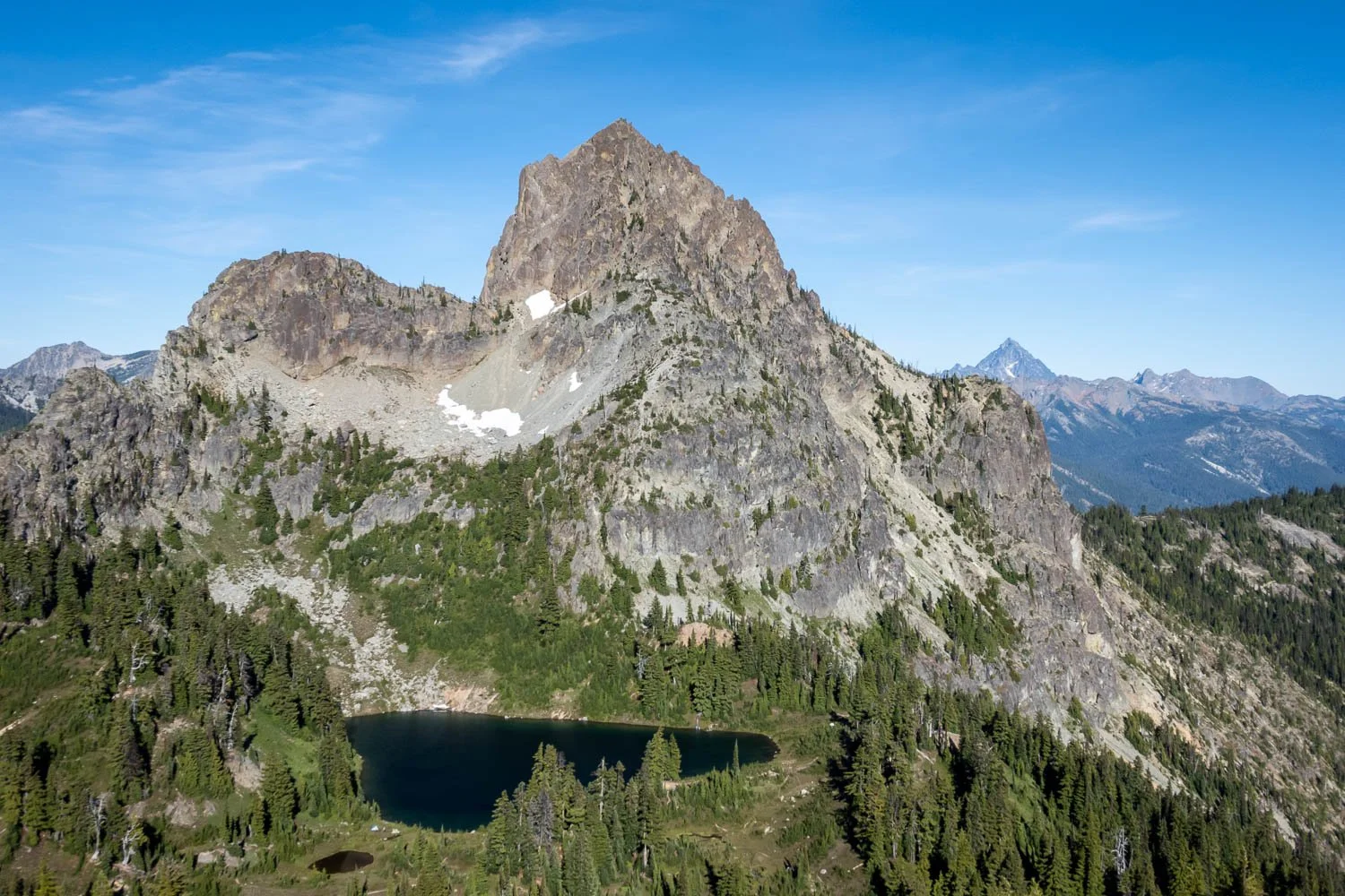
Cathedral Rock above Peggy’s Pond. Note Mount Stuart just to the right.
It was a hot afternoon, and I set out from the Tucquala Meadows trailhead thankful that it was late enough in the day for the climb to Squaw Lake to be mostly in the shade. The flowers and peak-a-boo views of Cathedral Rock were lovely, and soon I was traversing the steep hillside above Deep Lake towards Peggy’s Pond. I filled up some water and started up the climbers’ trail up towards Daniel. Once above treeline, the views, flower, and light all just kept getting better! What a cool angle of the peaks all along the Cascade Crest, with Lemah, Chimey Rock, Summit Chief, and Bears Breast all in a line. It was quite windy up high, and a descending party chastised me for not having crampons, two ice tools, and supplemental oxygen. I tagged the East Summit of Daniel, then traversed directly towards the main summit, which was somewhat chossy and unpleasant. Going slowly and taking lots of photos, I reached the true summit of Daniel and enjoyed the great views.
The Cascade crest all seen inline above Bears Brest from Daniel. Lemah, Chimney Rock, Summit Chief, Overcoat, and Little Chief.
Looking down the Lynch Glacier towards Pea Soup Lake, with Dip Top Peak and Lynch Peak separated by Dip Top Gap. Glacier Peak on the horizon in the distance.
I needed to get onto the Lynch Glacier in order to make my way down to Pea Soup Lake, but the top had melted out a little bit - nothing that a tasteful run-and-jump couldn’t solve. Once on the glacier, I cruised down the snow in beautiful evening light, then scrambled down some slabs on the skier’s lefthand side, aiming towards the outlet of Pea Soup Lake. The golden light and beautiful scenery were enough induce a state of near-paralysis, as I had to stop every 10 seconds or so to snap another photo. I spied a nice rock outcropping and balanced my camera in the appropriate spot to take a self portrait with the lake in the background, only discover that the remote shutter activation feature wouldn’t work without me signing into my Canon account, an impossible feat without cell service. WTF, Canon?? The 10 second self-timer would have to suffice, and after a few comical mid-sprint snaps, I finally got the photo I had imagined.
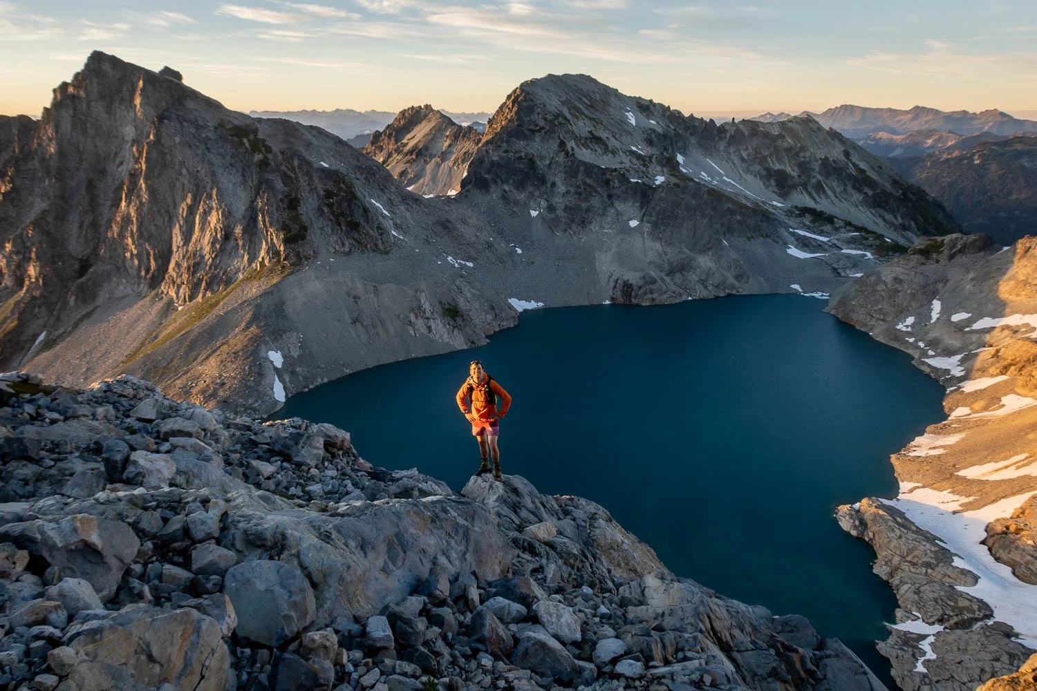
A hurried 10-second self-timer self-portrait above Pea Soup Lake, with Dip Top and Lynch Peaks in the background.
I continued down to the lake outlet, snapping far too many photos on the way. A little bit lower, the flowers were blooming in full force, and I found a delightful bivy site near the lakeshore just as it was getting dark. I filled up some more water, enjoyed a cold dinner, and snuggled into my bivy sack.
Looking down into the Foss River valley, with Paintbrushes in the foreground. It was very cool to have crossed both hydrologic (east to west) and accesso-logic (I-90 to Route 2) divides.
Dusk above Pea Soup Lake. Lynch Peak in the background.
Beautiful flowers on the shore of Pea Soup Lake, looking back at the Lynch Glacier and Daniel’s true summit (middle-right).
Having decided to forgo the sleeping bag, I was worried about being chilly, but by far the biggest impediment my sleep was the pre-dawn hour that my alarm went off. I dragged myself out of my nest and struggled into my trail runners. I boulder hopped up the morainal remnants towards Dip Top Gap, hoping to make it as far as possible before the sunrise would induce another bout of photo-paralysis. Unfortunately, the wildflowers made this case perhaps even more serious than the previous night’s, as every clump of blossoms presented a new foreground opportunity.
First light on Daniel and the Lynch Glacier, above Pea Soup Lake, with some nice asters in the foreground.
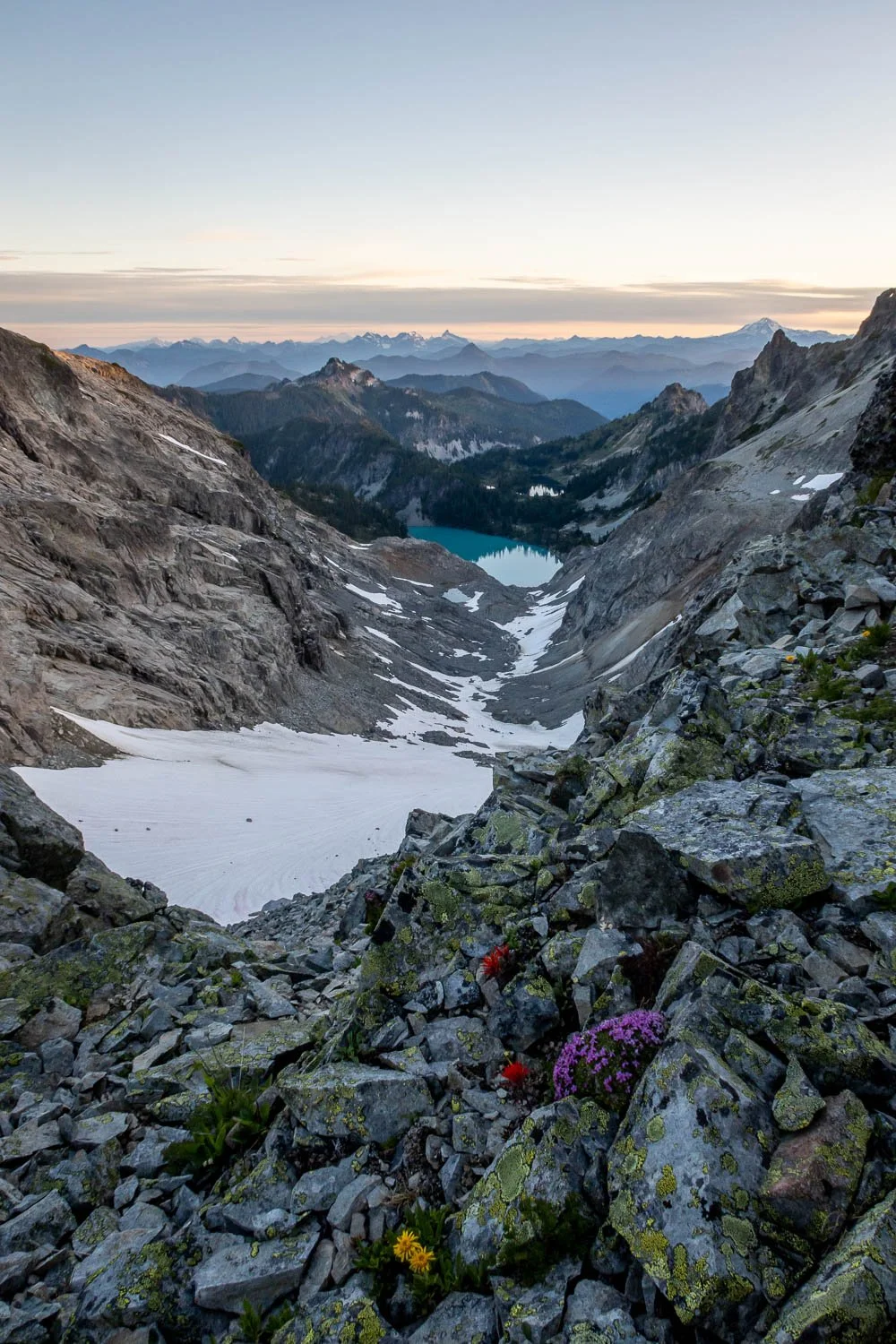
Looking north from Dip Top Gap down towards Jade Lake, with many prominent Cascades summits on the horizon, including Baker, the Monte Cristo Group, Sloan, and Glacier Peak.
I finally forced myself to put my camera away, and I scampered up towards the summit of Lynch, then retraced my steps back to Dip Top Gap and up Dip Top, whose lovely heather flowers brought on a brief rebound infection. Eventually, I dropped back towards Pea Soup Lake and grabbed the rest of my gear before dropping down to ~5,400 feet along the East Fork of the Foss River to circumvent steeper terrain before climbing up the dying glacier towards the saddle between Daniel and Hinman. Unfortunately, it was on this stint of off-trail travel that my knee started bothering me, a pain that would grow to become the dominant theme of the day.
Blooming heather below the summit of Dip Top. Daniel’s many summits all on display, along with some cool shadows on the Lynch Glacier.
Looking back at Dip Top from the saddle between Daniel and Hinman, with the dying easternmost lobe of the Foss Glacier in liquid form. Glacier Peak in the distance left.
From the saddle between Daniel and Hinman, I climbed easy talus and snow to the summit of Hinman, where I could eke out enough cell service for a brief appearance on the weekend’s family Zoom call. Here I faced a decision… I had originally planned on completing my loop back to Venus Lake by descending to La Bohn Gap, then heading over to Dutch Miller Gap and down into the Waptus River valley, a distance of almost 15 miles. However, Venus Lake was only a mere two miles of cross country travel away, and I was feeling awfully lazy. The knee pain nudged me towards the cowardly/conservative option, and I retraced my steps back to the Daniel/Hinman Saddle before heading around the top of the Shovel Creek drainage, through a tasteful amount of brush. I made brief conversation with a large frog while crossing the creek, then a few short and fun moves of easy scrambling brought me to the saddle NNE of Ares Peak. I said a brief hello to a fisherman on the shore of Venus Lake, the only human I had conversed with since leaving Peggy’s Pond, then headed cross country up towards The Citadel.
The sandy upper slopes of The Citadel were of the cursed “take one step forward, slide two steps back” variety, but soon snow made for easier travel on the east side of the ridge, and I dropped my pack for the short and fun scramble up to the summit. A summit register entry from the day before noted that Steve was worried about the downclimb, but I didn’t see any mangled human bodies, so I guess he made it down ok.
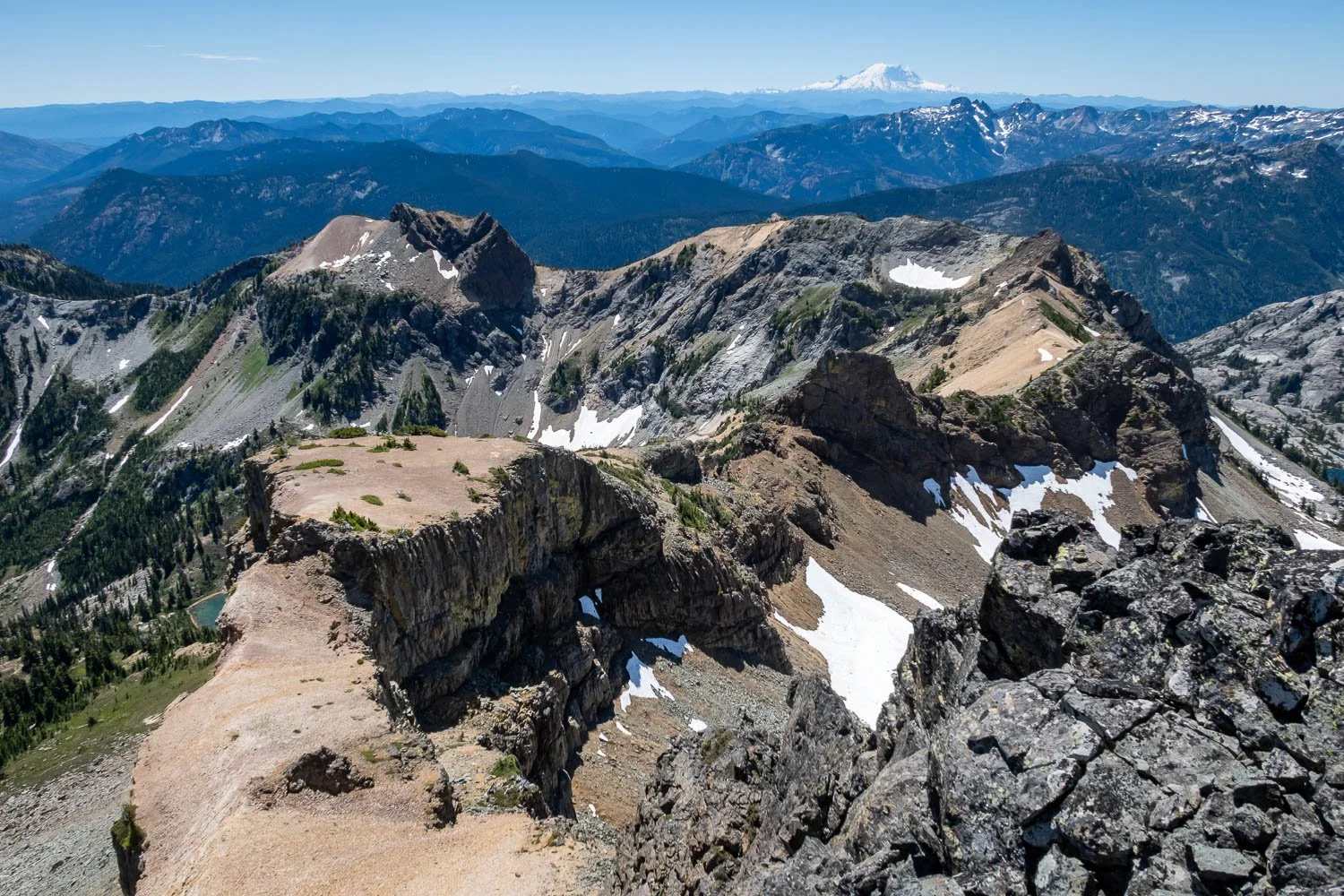
Cool topology looking south from the airy summit of The Citadel. Rainier in the distance.
From the Citadel, I could see my route up Daniel from the previous day, and it looked like I would succeed in closing my loop. I boot-skied down snow to the outlet of Circle Lake, where I surprised a couple sunbathing in the nude, then picked up the trail back up towards Daniel’s East Ridge and Peggy’s Pond. Around this point in the afternoon, the healthy dose of Ibuprofen I had taken earlier really wore off, and my knee properly sucked on the descent to Peggy’s Pond and back over to Cathedral Rock.
Cathedral Rock and flowers from the Cathedral Pass trail.
I had hoped that the superhighway of a trail back to Tucquala Meadows would be easier on the knee, but alas it was not. Thankfully I managed to stay ahead of the boisterous group of boys that I had passed back at Peggy’s, and I made it back to my car with only a few curse words. Despite the knee issues (a subsequent steroid injection and PT have me feeling optimistic), this was a truly wonderful solo trip!