The Chiwaukum Mountains run north-south for 12-or-so miles, sitting on the far side of Icicle Creek from their more famous neighbors, the Enchantments. The idea of traversing the mountain range on skis has appealed to me for a while, and bailing on a multiday attempt last year only amplified my enthusiasm. The weekend before last, Matt and I set out to try the traverse again, this time in a single push. We succeeded, and enjoyed solitude, great views, and atrocious skiing conditions. I will admit to a certain amount of hubris here: our planning process consisted mostly of asking “what’s a big single-day mission we could pull off” rather than “where might we find good skiing.” Perhaps we should have thought a bit more about the latter question after it rained torrentially up to 8,000+ feet and then re-froze…
We set off from Leavenworth a little bit past 5am, having dropped my car at Cascade Meadows the night before. Our plan was to drive as far up the Icicle as possible until we got Matt’s truck stuck, and then pull out the skis - and that’s exactly what we did. We made it almost a mile past Johnny Creek, just over two miles shy of the Chatter Creek trailhead. We dug until we could get Matt’s truck off the road, then set off skinning just as it was starting to get light. We skinned for a pleasant five minutes, just past the first bend in the road, before (classically) encountering a completely bare stretch of road. We switched back to trail runners, strapped the skis on our packs, and contented ourselves with postholing all the way up the mostly snow covered road to Chatter Creek. The trail was mostly snow-free until the second creek crossing at around 4,300 feet.
Matt, legs freed of their prisons/pants, charges up the Chatter Creek trail in the early morning, with some nice icicles on a fallen log.
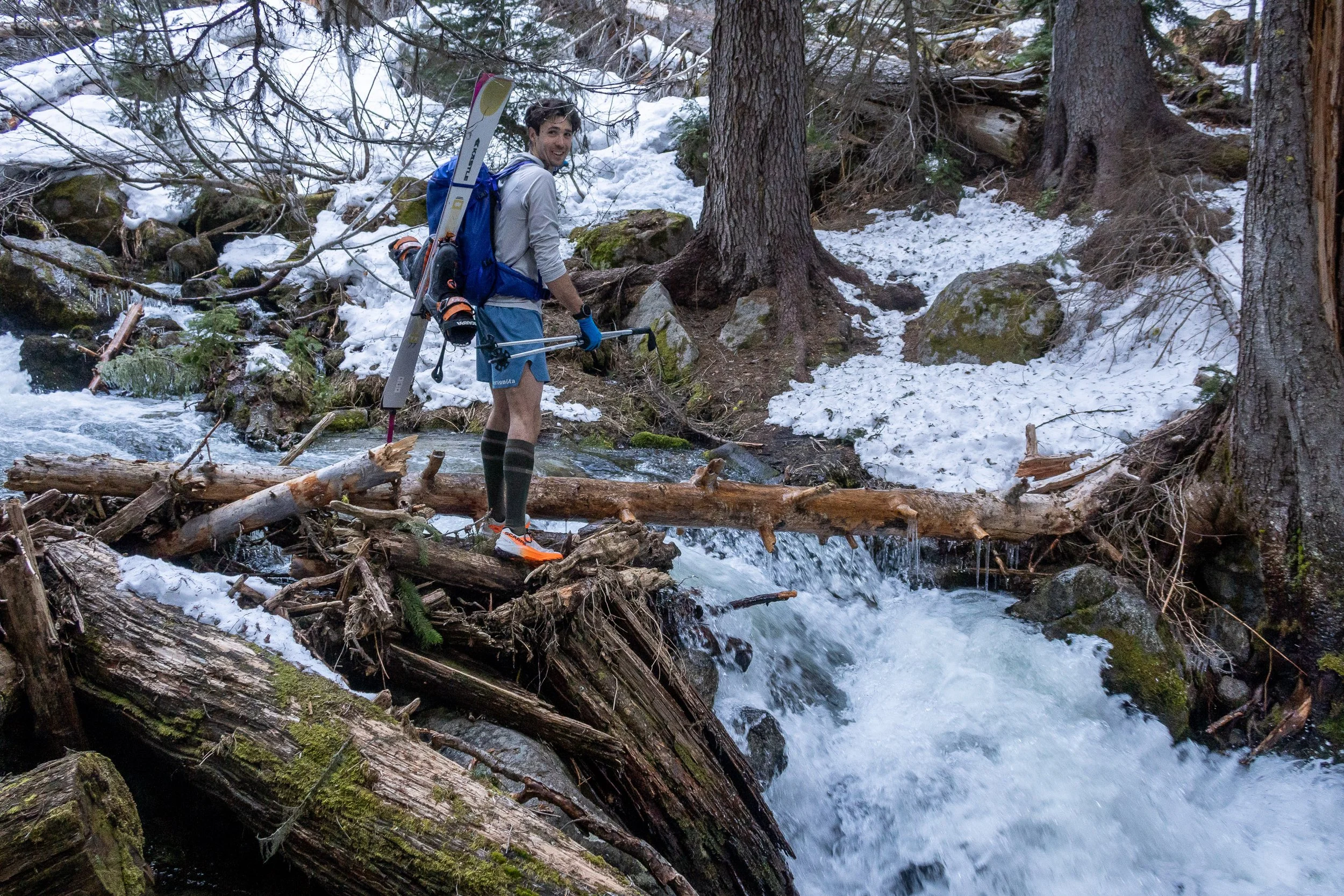
Our first challenge: crossing Chatter Creek on this ice-coated log…
At the creek crossing, we faced our first challenge: crossing Chatter Creek. We were presented with our choice of several narrow and extremely icy logs, all of which looked unpleasant. Matt and I tried two separate strategies, both of which at least kept us dry, even if our dignity was compromised. On the far side of the creek, the trail faded into the snowpack, but it was firm enough that we opted to keep walking until we were in the upper basin at around 5,200 feet. With our first views of Grindstone Mountain, we transitioned back to skinning, and headed up valley in the sun, climbing past two headwalls. We crossed the ridge dividing the Chatter Creek and entered into the Index Creek drainage, and opted to rip skins for a short traversing descent to flatter terrain. The skiing was terrible - a taste of what was to come.
We put skins back on for the gentle climb past Lake Edna to Cape Horn, as far as Jaclyn and I had made it on our last attempt. Once again, the north-facing slops on the far side of Cape Horn were steep and nasty, so we traversed high on skins towards Ladies Pass, booting the last little bit. We stayed on the southeast ridge of Point 7708 a bit further, then again ripped skins and made a descending traverse to ~6,800 feet, crossing a bowl to gain the mellower slopes above Lake Brigham. From there, it was a pleasant sunny climb up the nondescript south slopes of Snowgrass Mountain around 13:00.
Climbing up the mellow southern slopes of Snowgrass, with Cape Horn in the distance at middle-left.
Matt skinning a few hundred feet below the summit of Snowgrass, with Snowgrass’ eastern summit (Point 7640+) in the background.
Stuart and the rest of the Stuart Range looking nice to the south.
A nice day to be on the summit of Snowgrass. Note Rainier and Daniel in the distance.
While the south side of Snowgrass was snowy and mellow, the steep bowl on the north side was steep, shaded, and surprisingly devoid of snow. We eyed our exit gully that would bring us back to the crest of the ridge between Snowgrass and Big Chiwaukum, and, with some care, found a spot to drop in. The skiing on the north side was very steep and outrageously firm - definite survival skiing, and decidedly not fun, despite the spectacular setting. After descending about 800 vertical feet towards Upper Grace Lake, we cut hard right to start our climb east. There was no way we were skinning the mixture of steep, bulletproof icy snow and frozen loose scree, so we strapped skis on our packs, grabbed out ice axes, and slowly booted our way towards the exit gully. We really ought to have brought boot crampons, given the poor conditions. The frozen scree ribs were especially unpleasant, with the rock and dirt encased in a slippery inch of ice. When you got your footing ostensibly secure, the ice would unexpectedly break, dumping you into a surprisingly loose spot of dirt and choss. Thankfully, the going nearer the gully was easier, and before long we hit the ridge crest and popped back into the sunshine and soft snow on the east side of the ridge.We ripped skins and traversed down to 7,200 feet to get below a steeper ridge, then climbed past some big old avalanche debris piles on easy terrain until we were just a hundred feet or so below the summit of Big Chiwaukum, right above the famous Big Chiwaukum Couloir.
Matt dropping into the northern bowl on Snowgrass, with Big Chiwaukum in the distance. Our exit gully is at the sun-shade line directly above Matt’s backpack.
Having skied the slope in the upper left of this frame, we were mildly gripped booting out of the bowl - it really would have been a good idea to bring boot crampons.
Back on the east side of the range, the skinning was downright pleasant on our way up to Big Chiwaukum.
Earlier in the day, we had thought that the couloir might be on the menu, but after experience on the north side of Snowgrass, we weren’t so sure today was the day for it. Indeed, peering into the couloir from above, it looked heinous, fully of frozen slide debris and nastiness. Oh well - it would have to wait for a different day. Since the summit of Big Chiwaukum also looked unpleasantly steep and exposed to solo, we instead took a nice lunch break before ripping skins for our penultimate descent, down towards Cup Lake. It was easy and fast traversing to the saddle just west of Point 7410, but again, descending the steeper north facing slopes beyond was properly fucked (sensing a pattern here?). The bowl above Cup Lake, despite being north facing and at almost 7,000 feet in elevation, was almost unskiable, with icy snow interrupted by a narrow choke that was barely a ski-length wide. We engaged in some undignified sidestepping to get past it and onto the easier slopes below. We skied past Cup Lake and down Chiwaukum Creek, past some more massive avalanche debris piles, which forced us to cross to the eastern side of the creek. Crossing back left was nontrivial, but as usual, Matt demonstrated a remarkably gymnastic technique to mount the snowbank. At around 5,600 feet we put skins on for our last climb, making a rising traverse before climbing up steeper south facing slopes to the saddle west of Point 6935. We traversed west towards Point 7132, then ripped skins and shuffled over towards the top of the Swath at Point 6602.
The slopes above Cup Lake offered truly atrocious skiing with a rocky choke.
Skating alongside Chiwaukum Creek below Larch Lake. We exited over the notch above the creek at middle-left.
Matt surmounts the snowbank while crossing Chiwaukum Creek by obeying the “three points of contact rule”: two inverted ski poles and the tail of one ski.
The Swath drops quite steeply down to Cascade Meadows from the northern end of a broad alpine plateau, and the contrast was quite stark. Behind us was gentle and sunny open slopes, and in front of us was the steep, shaded slide path that drops over 4,000 feet straight down. We dropped in, and, after a few intimidating first turns, we found our rhythm, skiing slopes that were more comically firm than scary. At 3,800 feet, we bailed out of the slide path onto the old logging road, now a mere 3.5 miles of easy road from the car - right? Of course not! Every few minutes of skiing were interrupted by bare patches, creek crossings, or downed logs that necessitated removing skis. Lower down, we decided to switch back to trail runners, thinking we were running out of snow, but the grass is always greener, and we were subjected to plenty of unpleasant post-holing. By the time we reached Whitepine Road I was so fed up with post-holing that I convinced Matt to put our skis back on, and we skied down the road, spending a fair share of the remining distance walking through a few inches of standing water on the road. Finally, just before sunset, we reached my car.
A nice view of Mount Howard and Mount Mastiff with Glacier Peak in the distance. We had skied from Rock Mountain (out of frame to the left) over Howard to Mastiff and beyond a few weeks earlier, so it was fun to get a view of our previous route.
Matt making turns in the Swath - steep!
The road exit offered plenty of obstacles to keep things interesting on our way down to the car.
We drove back to Leavenworth as it was getting dark, then we had to tackle our final challenge for the day - driving back up the Icicle to dig out Matt’s truck.